The original "ROBERTS' TRAIL"
An historic walking trail around Burton Bradstock
Burton Bradstock, on the river Bride, has its roots deep in the history of Dorset, dating from well before the Norman Conquest in 1066 and was well established in Roman times. The manor, originally known as Brideton, passed through many hands in the middle ages, ending up in the possession of the Pitt-Rivers family who held the Lordship until much of the village and surrounding farms were sold off in numerous lots in 1951 and 1958.
Since that date, the general character of the village has been transformed from the small and tightly-knit community of farmers, fishermen, flax spinners and home net makers to one with a large population of retired folk. The village, however, retains much of its old world charm and thatch as a result of the careful restoration, conversion and maintenance of the older properties and a mostly sensitive approach to the more recent housing developments.
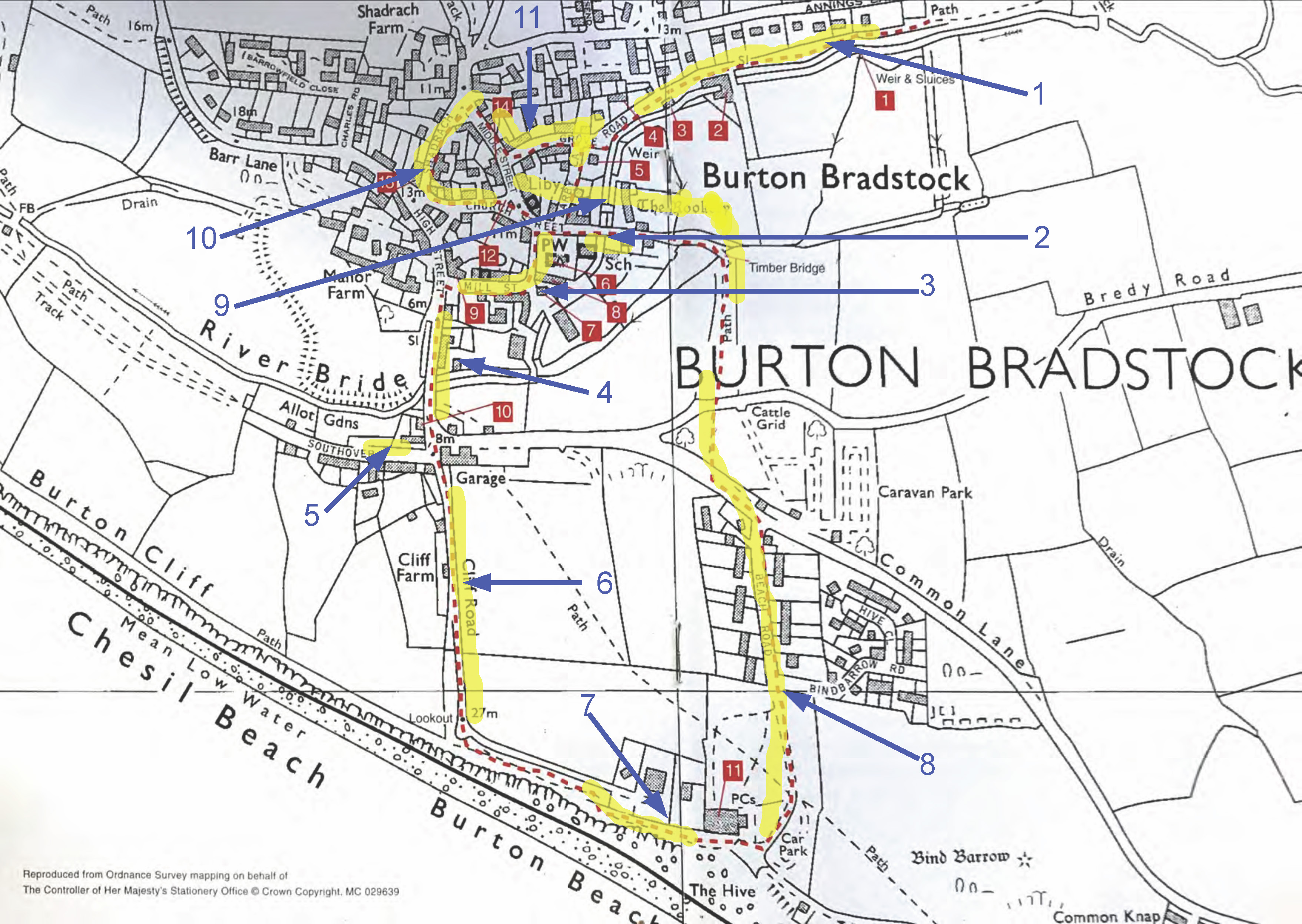
The entrepreneur Richard Roberts, in the latter half of the 18th century, probably did most to put Burton Bradstock on the map as he lived here whilst working to build up his country-wide, and eventually world-wide trade in flax and hemp based products. Many buildings and places in the village have associations with his life and work and these can be seen and enjoyed in a leisurely walk around the quiet back streets of this gentle place. This is best done with the aid of a pamphlet entitled " The Roberts' Trail" which gives a map and numbered guide to these and other sites of interest. This has now been updated by the "Trail and Tale " booklet
See some pictures taken along the trail
The original Roberts Trail Booklet - 2000
Dave Barnikel - The Roberts' Trail
Historic walk and chat around Burton based on the Roberts' Trail
Relates to map below |
Item |
Duration |
MP3 Audio |
Introduction |
0’36” |
||
| 1 |
Sluices to end of Grove Road |
1’18” |
|
| 2 | Darby Lane and Church |
0’40” |
|
| 3 | Mill Street | 1’32” |
|
| 4 | High Street | 0’52” | |
| 5 | Southover | 0’17” | |
| 6 | Cliff Road, cliffs and fishing | 0’50” | |
| 7 | Gun emplacements, villas | 0’37” | |
| 8 | Cafe and Beach Road | 0’26” | 413KB |
| 9 | Timber Bridge and back to the green | 0’28” | 438KB |
| 10 | New route past WI Hall | 0’30” | |
| 11 | Middle Street, Grove Road | 0’18” | 282KB |
Blue arrows and yellow markings on the map below show where Daves chats took place.