A description of the Jurassic formations around Burton Bradstock
Contributed by Richard Edmonds - Jurassic Coast Project Officer, Environmental Services Division, Dorset County Council. November, 1999.
Foreword: |
 |
| Those who know West Dorset will be aware of the wonderful diversity of cliffs, rocks and beaches in the area. They will also know of the constant cliff falls along the coast which expose a tremendous quantity and range of fossils for fossil hunters and geologists alike. As many of us wanted to know more about the geology around Burton Bradstock, Richard Edmonds kindly agreed to write this article giving a very interesting and detailed insight into the Jurassic geology of the area. Richard also explains the formation of and the issues around Chesil Beach. |
A description of the Jurassic formations around Burton Bradstock, and the structure of Chesil Beach
Introduction:
The Dorset coast contains a complete sequence of rocks from the Jurassic period of geological time and the reason is simple; generally speaking, the rocks dip gently to the east. As a result, the oldest Jurassic rocks are found in the west, around Lyme Regis (the Lower Lias at about 200 million years of age) and the youngest are found in the east, on Portland and along the Purbeck coast to Swanage, where they are about 135 million years old.
The completeness of the geological succession, the superb fossils that have been, and continue to be found along the coast and the geomorphological or erosional features that fashion the coast, form the basis for the current bid for World Heritage Site status for the Dorset and East Devon coast.
Below the Jurassic lie rocks from the Triassic period and these formed in a vast desert that once covered Britain. The start of the Jurassic is marked by a global rise in sea levels that flooded the desert. Initially the sea was deep and a thick sequence of clays were deposited. Towards the end of the Lower Jurassic the sea had become much shallower, laying down sandstones, the Bridport Sands and then, in the Middle Jurassic, limestones, the Inferior Oolite before deepening once again, allowing the deposition of clays, the Fullers Earth. These are the rocks that form the cliffs and underlie the village of Burton Bradstock.
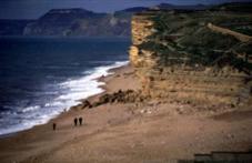
Burton Bradstock:
Between West Bay and Hive Beach, the towering cliffs are formed from Bridport Sands, rocks that formed at the front of a giant delta that fanned into the Jurassic sea from a landmass in the north. These same sands also form the sunken lanes that can be found on a line north from here to Yeovil and beyond. To the north these sands are older in age, providing the evidence that they were laid down in a delta that slowly filled the sea as it migrated south.
Capping the cliffs, particularly in the Freshwater area, is a thin sequence of limestone, the Inferior Oolite. Oolitic limestones are rocks that form in shallow sand banks such as the Bahamas today, and they are composed from countless millions of round structures known as ooliths. These structures consist of sand grains or shell fragments that are rolled around in a shallow, calcium rich sea, gathering layer upon layer of calcium carbonate. Because the limestone is made of a mass of these tiny balls, it can be cut in any direction, a quality that makes this a 'freestone' and as a result, the Inferior Oolite has been extensively quarried as a building stone. Indeed, the distinctive character of the village is due to the use of Inferior Oolite in many of the older buildings.
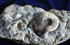 |
The Inferior Oolite is phenomenally rich in fossils, particularly ammonites (including the Genus Bredia, named after the Bride Valley), belemnites, shells (bivalves and brachiopods) and sponges but lying at the top of the vertically cliffs, it is inaccessible until large cliff falls bring the blocks to the beach. Beware, however, the cliffs are very dangerous, particularly after such events and you are advised to stay clear. A voluntary fossil collecting code of conduct has been agreed for the West Dorset coast and details can be found on the Charmouth Heritage Coast Centre web site at; http://members.aol.com/charhercen |
A large fault cuts through the rocks at Hive Beach and to the east the rocks are displayed downwards by approximately 30m. The Bridport Sands and Inferior Oolite disappear below sea level and the cliffs are formed from the overlying Fullers Earth Clay, which can also be seen in the cliff top directly east of Freshwater. In some parts of the country, notably the Frome area, this clay was quarried for its ability to absorb oil, a quality once used for cleaning wool.
In the east of the county, the rocks exposed around Burton Bradstock dip below the ground where they form part of the Wytch Oil Field that lies under Poole Harbour. Here, the porous Bridport Sands form one of the reservoir rocks for the oil and as a result, the cliffs at Burton provide petroleum geologists with a cross section of an oil bearing strata.
Chesil Beach.
Chesil Beach is one of the finest barrier beaches in Europe, if not the world, and geomorphologists are still arguing about how it formed and what is happening to it today. The beach is complicated in that the pebbles are graded from cobble size at Portland to pea sized at West Bay (but complex variations also exist across the height of the beach). The grading is due to the long shore drift. The prominent wind direction is from the south and southwest and therefore the sea strike the beach at an angle, carrying the shingle to the east. Less strong easterly and southeasterly gales carry the smaller shingle back to the west, creating the shingle size gradient.
The traditional view is that the beach was pushed onto the shore as sea levels rose at the end of the last Ice Age. A more recent suggestion is that a very considerable proportion of the beach came from the huge landslides of West Dorset that were far more active during the Ice Age than they are today. The shingle was carried to the east by Long Shore Drift, literally 'spreading' the beach to Portland. As with many theories, it is likely that a combination of both processes were involved in the formation of the beach.
There is evidence that the beach is moving on shore as the large storm events cause the beach crest to move back. Even more convincing evidence can be seen in the blocks of peat washed onto the beach in the West Bexington and Abbotsbury area. These formed within the Fleet when the beach was further out to sea but as the beach moves onshore, it rides over the sediments until they become exposed to erosion on the seaward side of the beach. There are now concerns that the beach no longer receives shingle from the landslides of West Dorset. Early admiralty charts indicate that the beach once ran around the front of headlands such as Golden Cap and Thorncombe Beacon. Today these are rocky shorelines along which long shore drift cannot take place and this is why the beach volume has declined on the west side of the piers at West Bay, causing a major concern in the coast protection of the harbour. So what about the long term future of Hive Beach and Burton Bradstock? Small sea defences already exist at Hive Beach but so long as the bulk of the beach remains, the car park area will remain protected. The cliffs through to West Bay continue to erode, usually through spectacular cliff falls that are rapidly washed away, a process that is virtually impossible to stop.
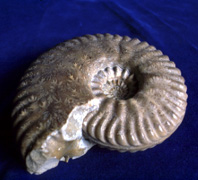 |
Bredia named after the Bride Valley |
Other Geology Related Web Sites:
Charmouth Fossil Shop Now showing the new Ichthyosaurus recently found locally. updates as it is cleaned and fully identified.
Charmouth Heritage Coast Centre
http://members.aol.com/charhercen
University of Southampton
The university maintains an extensive web site on the geology of the
Dorset coast
www.Soton.ac.uk/~imw/portbib.htm
Dorset Coast Forum
Information about the coast including the 'Jurassic Coast Project'
www.dorset-cc.gov.uk/dcf